It often seems that the deeper one goes into any subject, the less the matter hinges on isolated facts and the more it reveals itself as a question of orientation. What are we really looking at, and just as importantly, what are we looking through? Somewhere between inherited certainty and independent inquiry lies a more difficult path — one that asks not only whether a claim is true, but what framework made it appear obvious in the first place. That, perhaps, is where this discussion properly begins.
. . .
In this discourse we explored far more than the historical details surrounding Greenland, old maps, or the Lost Squadron. The discussion widened into a reflection on how knowledge is formed, inherited, defended, and sometimes quietly constrained by institutions, paradigms, and hidden dependencies. Along the way, we considered the difference between evidence and interpretation, the value and risk of independent research, and the importance of cultivating enough intellectual flexibility to move through competing models without becoming imprisoned by any one of them.
Key Points Discussed
- The basic facts of the Lost Squadron story are historically sound, including the later recovery of one aircraft from deep beneath Greenland’s ice.
- The rapid burial of the aircraft does demonstrate that substantial ice accumulation can occur over a relatively short span of time under certain conditions.
- That observation alone does not overturn conventional ice-sheet chronology, though it does challenge simplistic assumptions about uniform rates of accumulation.
- Early maps showing Greenland without obvious ice coverage are intriguing, but they do not by themselves prove an ice-free Greenland in the recent past.
- Historical maps must be read carefully, with attention to their purpose, conventions, limitations, and the worldview of their makers.
- The discussion shifted from specific evidence to the larger question of how evidence is interpreted within a given paradigm.
- Thomas Kuhn’s notion of theory-laden observation became central: people do not interpret evidence from a neutral vantage point.
- Modern scholarship depends heavily on delegated knowledge, which is necessary, but can conceal hidden dependency when multiple claims trace back to the same unexamined assumptions.
- Apparent consensus is not always the same thing as multiple independent lines of evidence.
- Institutional systems can reinforce narrow intellectual boundaries without requiring overt conspiracy or deliberate deception.
- Suppression of truth may be explicit in some cases, but more often takes the form of omission, filtration, simplification, and derivative teaching.
- Independent researchers may sometimes see what institutions overlook, particularly when they are willing to pursue old or neglected source material.
- Independent inquiry is not automatically superior; it remains vulnerable to confirmation bias, pattern fixation, and interpretive overreach.
- A more disciplined form of inquiry was proposed: paradigm mobility — the ability to inhabit a framework provisionally without becoming its defender.
- Related to that is reversible conviction: holding an idea firmly enough to test it, but loosely enough to revise or abandon it.
- The deeper issue is not simply “What is true?” but “What must I already believe for this evidence to appear obvious?”
- Worldviews often become entangled with identity, community, and career, making contrary evidence feel like a threat to the self.
- The conversation closes with a practical intellectual ethic: take what nourishes, test what appears useful, discard what does not withstand contact with reality, and don’t linger.
Key Takeaways
- Evidence and interpretation are never entirely separable.
- Hidden dependency weakens the appearance of independent confirmation.
- Institutional knowledge can preserve truth and distort it at the same time.
- Independent study matters, but so does disciplined self-scrutiny.
- The most useful posture may be neither belief nor disbelief, but engaged provisionality.
» Trance:
I’ve heard of something called the Lost Squadron of 1942. Apparently, it was a squadron that got lost and needed to make an emergency landing, I believe in Greenland. Everyone was apparently rescued.
In 1992, one of the airplanes was excavated, and I think it was found under about 264 feet of ice. This would seem to suggest that the uniformitarian model of an ice age may be woefully inaccurate, at least as far as the time frames involved.
Regardless, I’m curious whether this can be fact-checked.
» ChatGPT:
Yes. The basic story checks out remarkably well.
On July 15, 1942, a group of eight U.S. Army Air Forces aircraft—six P-38F Lightnings and two B-17 bombers—were being ferried across the North Atlantic toward Britain when deteriorating weather and fuel concerns forced them to land on the Greenland ice sheet. All of the crewmen survived and were subsequently rescued. The aircraft were abandoned. (Smithsonian Air and Space Museum)
Over the following decades they disappeared beneath the ice. Numerous expeditions tried to relocate them. Eventually one of the P-38s was located and, in 1992, recovered from approximately 268 feet (82 metres) below the contemporary ice surface. That aircraft became known as Glacier Girl. The Smithsonian confirms the 268-foot figure and the 50-year interval. (Smithsonian Air and Space Museum) The P-38 Association’s history independently gives the same depth, and contemporary reporting describes the extraordinary hot-water shaft used to reach it. (P38 Association)
So your memory is essentially correct: 1942 → 1992 → ~268 feet down.
And you’re right that, at first sight, this is an astonishing amount of ice over a human lifetime. Simply dividing gives:
268 ft ÷ 50 years ≈ 5.36 feet of vertical burial per year.
But there’s an important distinction here. That calculation does not mean Greenland created 268 feet of solid glacier ice from snowfall at a uniform rate of 5.36 feet of solid ice annually.
The aircraft landed in southeastern Greenland, which is an exceptionally high-precipitation part of the ice sheet. Measurements show that snowfall accumulation varies enormously across Greenland. NSIDC gives values below 0.1 metre water-equivalent annually in parts of northeast Greenland but more than 1 metre water-equivalent annually in parts of the southeast. (National Snow and Ice Data Center) Some published work reports southeastern precipitation commonly exceeding 1–2 metres water-equivalent per year. (AGU Publications)
Modern airborne radar measurements similarly find southeastern Greenland accumulation averaging roughly 0.5–1.2 metres water-equivalent per year, with substantial local and year-to-year variation. Interestingly, that research also found regional climate models can misrepresent the extreme spatial variation in coastal snowfall. (NOAA Institutional Repository)
There is another important factor: the ice itself moves and deforms. A glacier isn’t a stationary stack of annual snowfall sitting on bedrock. It flows downhill under its own weight, compresses vertically, stretches horizontally, and transports buried objects with it. USGS defines glaciers specifically as accumulated snow and ice that move downslope under gravity. (US Geological Survey)
Consequently, “268 feet below the 1992 surface” represents the aircraft’s position within a moving, compacting ice system after fifty years. It isn’t simply a 268-foot ruler measuring fifty years of freshly manufactured solid ice.
Where I think your larger question becomes genuinely interesting is the distinction between rapid ice accumulation and the age of an ice sheet.
The Lost Squadron absolutely demonstrates that:
Very large thicknesses of snow, firn and eventually glacier ice can accumulate within decades.
That is an empirical observation—not a model.
But it does not by itself demonstrate that the Greenland ice sheet is young, because ice-sheet chronology isn’t normally calculated by taking present-day thickness and dividing it by a presumed constant annual accumulation rate.
In fact, doing that would be a pretty bad model. Accumulation differs enormously by location and climate regime, and deep ice becomes compressed and thinned as it flows. Modern ice-core dating therefore uses combinations of identifiable annual layers, volcanic horizons, chemical/isotopic signatures, flow modelling and other independent markers.
There’s actually a useful conceptual distinction here:
How quickly can 268 feet accumulate?
and
How long has the ice underneath it existed?
Those are completely different questions.
Imagine a 1,000-year-old forest floor onto which five metres of snow falls during an extraordinary series of winters. The rapid formation of the upper five metres tells you nothing directly about the age of the material underneath.
Likewise, Glacier Girl gives us an unusually good dated marker horizon: we know exactly when those aircraft were placed on the surface—July 1942. Their later position therefore provides an excellent empirical measurement of local accumulation and ice deformation since then. It does not extrapolate straightforwardly to the age of ice thousands of metres farther down.
There is another fascinating consequence, though. Cases like this are a very good warning against simplistic versions of uniformitarian reasoning.
If someone reasoned:
“Glacier ice accumulates only a few millimetres per year, therefore hundreds of feet necessarily represent tens of thousands of years,”
Glacier Girl would demolish that argument.
But modern glaciology doesn’t actually make that assumption. Greenland accumulation rates are explicitly understood to vary dramatically spatially and temporally. (Cambridge University Press)
So I’d phrase the verdict this way:
The historical claim: true.
The extraordinary burial rate: true.
The conclusion that this falsifies conventional ice-sheet chronology: not established by the aircraft alone.
The conclusion that thick ice can form surprisingly rapidly under suitable conditions: unquestionably true.
And there is an even more interesting avenue to pursue if you’re questioning the conventional chronology: annual layers in Greenland ice cores. That’s much more consequential than Glacier Girl because the conventional dates ultimately depend heavily upon whether increasingly deep layers really can be reliably identified as annual, particularly where compression, diffusion, deformation, melt layers and uncertain accumulation enter the picture.
That is where we could actually stress-test the “100,000+ years of Greenland ice” claim rather than merely arguing by analogy from Glacier Girl. USGS currently states that Greenland contains ice more than 100,000 years old. (US Geological Survey) We could look at how they know that, where direct annual counting stops, what assumptions enter afterward, and whether independent dating methods converge on the same chronology. That would get much closer to the heart of the question you’re raising.
» Trance:
Are there not maps less than a millennium old that show Greenland free of ice?
» ChatGPT:
There are indeed maps from the last millennium that are sometimes presented as showing Greenland “ice-free,” but that claim needs an important qualification: I cannot find a historical map that reliably demonstrates that the Greenland ice sheet itself was absent within the last 1,000 years.
What does exist are several intriguing early maps in which Greenland is drawn as ordinary land, sometimes with mountain ranges, rivers, bays, or internal geography and with no obvious ice sheet depicted. The famous examples are mainly 15th- and 16th-century maps rather than genuinely ancient ones. One early portolan chart from about 1502–1506 already depicts part of Greenland. (The Library of Congress) Later maps associated with Mercator, the Zeno tradition, and other Renaissance cartographers can make Greenland look strikingly unlike the vast white ice-covered island familiar from modern maps.
But absence of drawn ice is not equivalent to evidence of absence of ice. Renaissance maps generally weren’t thematic physical maps in the modern sense. A cartographer drawing coastlines, settlements, mountains and place names wasn’t necessarily trying to represent the extent of glaciers. And these maps contain substantial geographical errors elsewhere. The Zeno-derived cartographic tradition, for example, famously propagated the nonexistent island of “Frisland” around the North Atlantic for roughly a century. (Reddit) That makes it difficult to treat details of Greenland’s interior as eyewitness surveying.
There is, however, a related fact that is quite real and sometimes gets conflated with the “ice-free Greenland” claim: large parts of Greenland’s coast were—and still are—ice-free. Greenland today is about 80% ice-covered, meaning roughly 20% isn’t underneath the main ice sheet. (AntarcticGlaciers.org) Southern and southwestern Greenland have substantial ice-free valleys, fjords and pasture-like areas.
That’s exactly where the Norse lived. Erik the Red’s settlement began around AD 985, during the Medieval Climate Anomaly, and archaeological sites occur across the ice-free southern and western coastal regions. (Nature) So medieval descriptions of habitable Greenland, grazing land, farms, churches and substantial settlements aren’t mysterious evidence that today’s central ice sheet wasn’t there. Those places genuinely were—and remain—outside the central ice sheet.
Where things become more interesting is when we go farther back than 1,000 years.
There is good mainstream geological evidence that the Greenland Ice Sheet has changed considerably in size during the Holocene. Models and geological evidence indicate that during the early-to-mid Holocene climatic optimum, several thousand years ago, the ice sheet was smaller than today. (Cambridge University Press) That is not controversial.
But that’s still very different from the proposition that Greenland was essentially ice-free around AD 1000–1500.
And there is a particularly strong reason for skepticism about that latter claim: researchers can trace stratified Holocene and older ice across Greenland itself. Radar mapping identifies the transition between Holocene and late-glacial ice deep inside the sheet, with the conventional chronology putting that transition around 14,700 years ago. (Cambridge University Press) Whatever one thinks about exact ice-core dating, an explanation in which virtually the entire Greenland ice sheet accumulated after medieval times would have to account for that internal stratigraphy, not merely the surface accumulation rates.
So I would distinguish three claims:
- “Old maps depict Greenland without a white ice cap.” — Yes.
- “Medieval Greenland contained extensive habitable, green, ice-free territory.” — Absolutely.
- “Those maps establish that the central Greenland ice sheet didn’t exist less than 1,000 years ago.” — No; the maps don’t establish that.
What I would not do, though, is dismiss the old maps merely because they disagree with modern expectations. Some deserve examination individually.
In particular, I suspect the maps you’ve encountered may be the Zeno map (1558), Mercator’s maps, possibly the 1531 Oronce Fine/Finaeus map, or maps discussed by Charles Hapgood. There is a modern paper making exactly the argument you’re remembering—that 16th-century maps depict Greenland without coastal ice—but it is not representative of the mainstream interpretation. (Academia)
If you’d like, I can pull up the actual historical Greenland maps from roughly 1400–1600 and put them in chronological order, rather than relying on what people on either side claim they show. That’s probably the most interesting way to investigate this: look at the maps themselves, their provenance, what Greenland actually looks like on each, and whether features depicted on them correspond to known geography beneath today’s ice.
» Trance:
Let’s see them.
» ChatGPT:
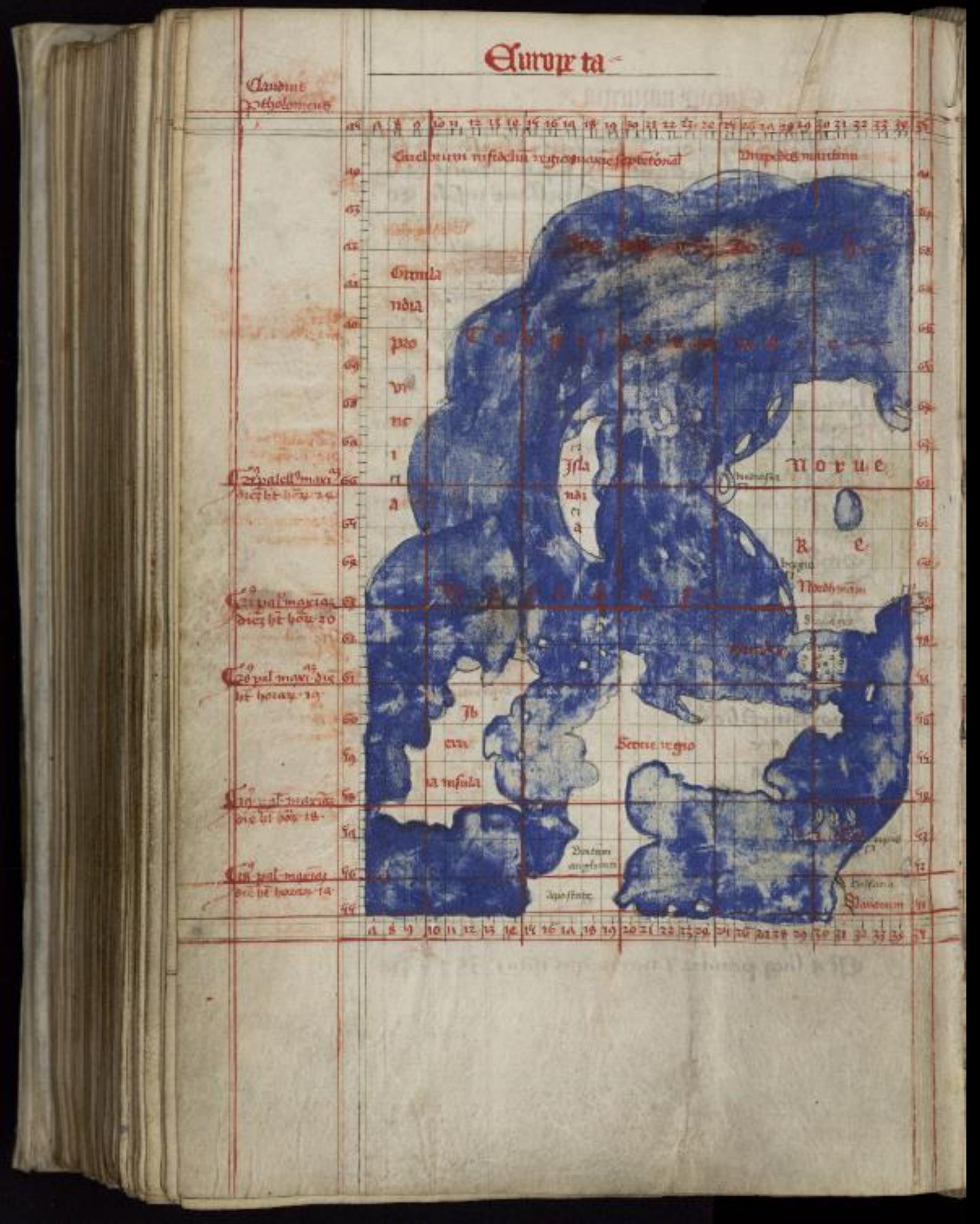
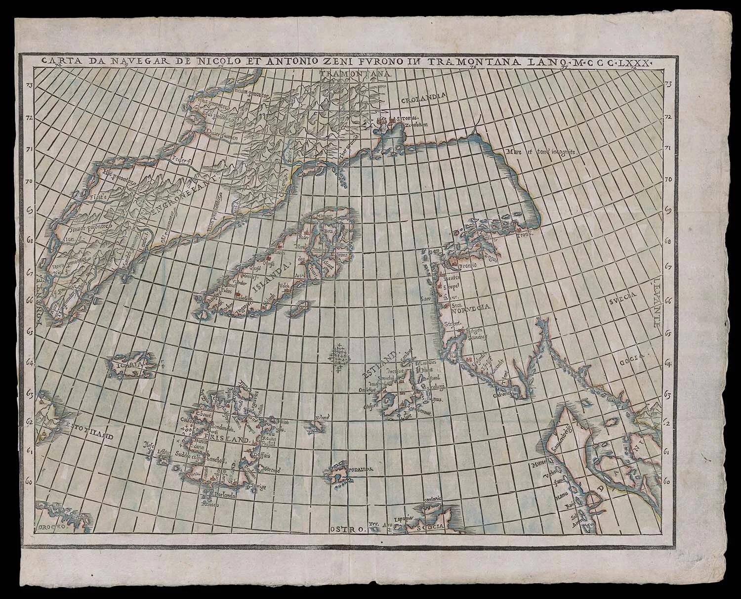
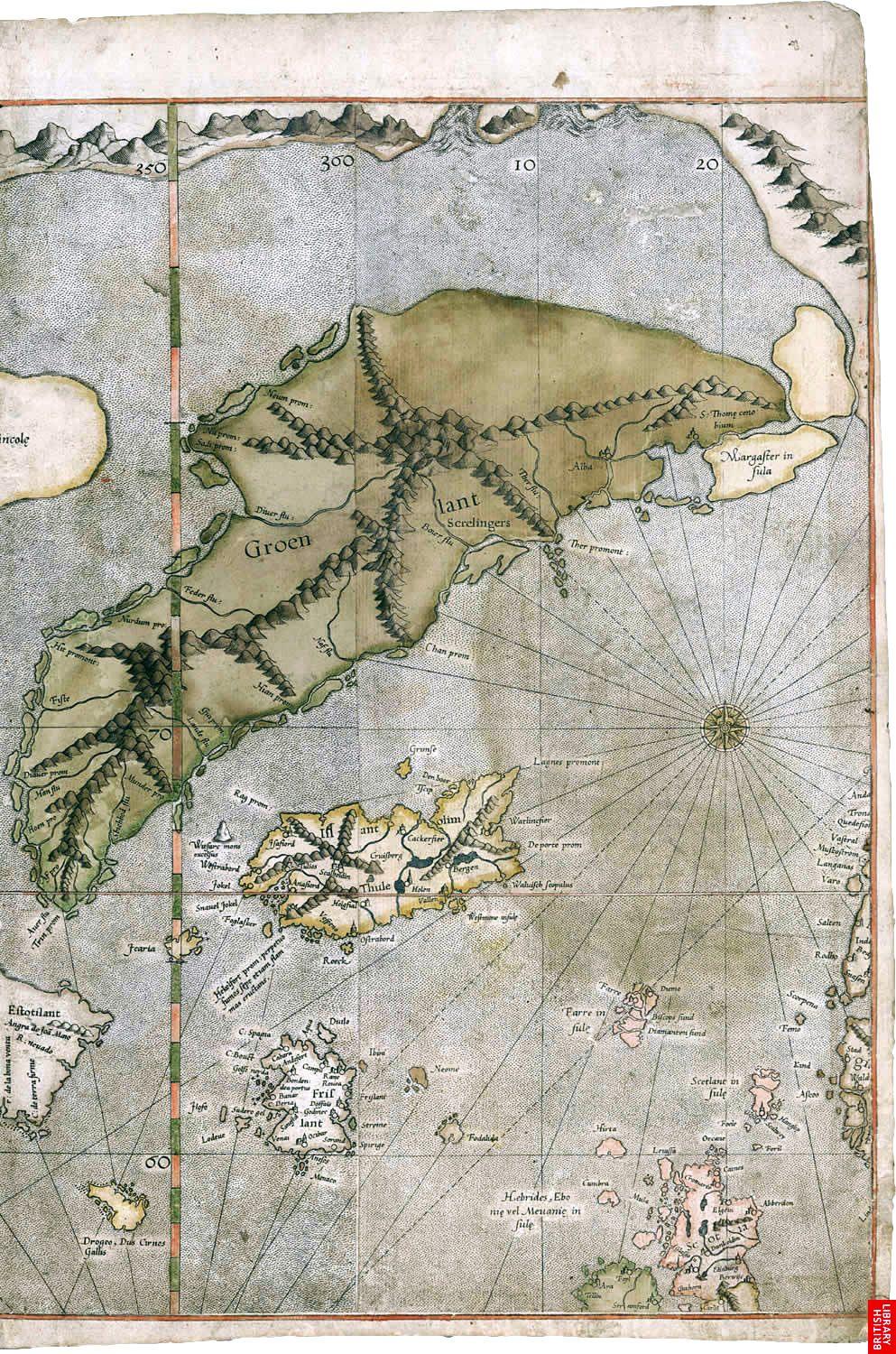
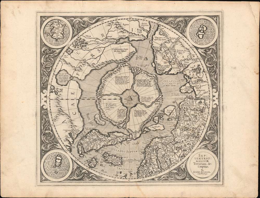
Here are four useful examples, in roughly chronological order. They’re interesting precisely because Greenland is generally rendered as ordinary terrestrial geography—coastlines, mountains, settlements or place names—not as a giant featureless ice cap.
The first is associated with Claudius Clavus, c. 1427. Clavus was a Danish cartographer and one of the earliest Europeans after the Norse period to produce maps incorporating Greenland into a broader northern geography. The surviving maps are imperfect and stylized, but Greenland is treated as land rather than depicted with any obvious continental-scale ice covering.
The second is the famous Zeno map of 1558. This is where things get more complicated. Nicolò Zeno the Younger claimed the map derived from voyages made by his ancestors around 1380. The published map depicts Greenland—“Engronelant”—with a surprisingly elaborate coastline and internal mountain symbols. But it also contains Frisland, a nonexistent island, and the underlying voyage narrative is regarded by most cartographic historians as unreliable or fabricated. The original 1558 book survives in the Library of Congress. (The Library of Congress)
Then look at Mercator’s Greenland on his 1569 world map:
This is probably the most visually striking one for the question you’re asking. Greenland is drawn with extensive mountain ranges running through its interior, coastal valleys and numerous geographic labels. There is no graphic indication of an enormous ice sheet occupying ~80% of the island.
But there is a major caveat: Mercator borrowed substantially from the Zeno cartographic tradition when constructing Greenland. The later David Rumsey description of Mercator’s Arctic map explicitly notes that the Greenland outline was inspired by the Zeno map. (David Rumsey Map Collection) So this isn’t necessarily independent testimony from another explorer who surveyed an ice-free Greenland.
Finally, Mercator’s 1595 Septentrionalium Terrarum descriptio gives us an even clearer Arctic view:
Again, Greenland appears as a mountainous land mass. But this map also illustrates why we have to be cautious about treating every depicted geographic feature literally. Mercator’s North Pole consists of four enormous islands separated by four rivers flowing toward a central polar feature—geography that modern exploration has not confirmed. The Rumsey collection itself describes that representation as deriving from contemporary geographical mythology. (David Rumsey Map Collection)
So after actually looking at them, I think there are two conclusions worth keeping simultaneously.
First, you were remembering something real. There absolutely are maps only ~400–600 years old depicting Greenland in ways that look nothing like the familiar modern white ice-cap representation. Anyone saying “no such maps exist” would simply be wrong.
But second, I don’t think these maps on their own constitute good evidence that Greenland was substantially ice-free in the fifteenth or sixteenth century. Early-modern cartographers routinely drew mountains across regions whose interiors they had never surveyed, copied one another extensively, and included geographical features we now know did not exist. Mercator’s dependence upon Zeno is particularly important because what initially looks like two independent witnesses may actually be largely one cartographic tradition being repeated.
There is, however, a much more provocative question hiding underneath this.
The really interesting evidence wouldn’t be whether a Renaissance cartographer failed to draw ice. It would be whether one of these maps depicts specific Greenland topography that is now buried beneath the ice, and whether modern ice-penetrating radar has subsequently discovered that same topography.
That would be a completely different evidentiary situation.
For example, if a 1500s map showed a valley, mountain range, river drainage or fjord in Greenland’s present interior, and modern subglacial radar showed essentially that same feature beneath 1–3 km of ice, then we’d have something requiring a serious explanation. “Cartographers didn’t bother depicting glaciers” wouldn’t explain how they knew the buried geography.
I’ve encountered claims along those lines, especially involving the Zeno and Mercator maps, but I don’t want to repeat them until we’ve checked them against the actual modern BedMachine/subglacial Greenland maps.
That’s probably our next worthwhile comparison: old-map Greenland versus the modern radar-derived map of the land underneath the Greenland Ice Sheet. That would allow us to see whether the resemblance people claim is genuinely impressive or largely pattern-matching.
» Trance:
The same issue persists with Antarctica, which is shown as green and ice-free, with animals of all kinds roaming about, on certain maps several centuries old. And the idea of a paradigm or tradition being copied and repeated seems to be par for the course throughout human history.
We’ve experienced it viscerally in the modern era, with certain institutions and systems of governance carrying on in incredibly anti-human, illogical, tyrannical, even deadly ways based on ideas that are outdated, debunked, dismantled, yet strangely perpetuated anyway for whatever reason — usually political, financial, or ideological, though perhaps even spiritual or otherwise.
Regardless, we’re tapping into the root of something fundamental about the “human condition” that we’ve tried to explore many times in previous discourses.
You say, “Frisland doesn’t exist,” rather offhandedly, and make a number of other presumptions and assumptions throughout your response. All manner of historical records, as well as physical elements of our reality — architecture, libraries, artifacts, strange or narrative-challenging finds in the strangest of places — are routinely erased, repurposed, misrepresented, or overwritten.
As to the use of modern technology to view “subglacial” geography, are they sharing everything they find? Are they cherry-picking what fits the model or established narrative? Are they even capable of seeing, or perceiving, something so contrary to what they expect to find?
I would suggest that sources such as Google Maps and Google Earth cannot be fully trusted, given the nature of their data gathering and the political, financial, corporate, and shared military interests involved. They have been caught hiding, obscuring, or obfuscating things people have seen with their own eyes.
As to the North Pole, who is actually allowed to go there? The same goes for Antarctica. Much of it is effectively out of bounds.
» ChatGPT:
Yes—this is the more fundamental epistemic problem. Institutional consensus is evidence, but it is not the same thing as reality. Institutions can preserve error through incentives, professional conformity, inherited assumptions, classification, bureaucratic inertia, political pressure, or simple inability to recognize an anomaly. History gives us plenty of examples. But the same standard has to cut both ways: distrust of an official narrative cannot itself establish the competing narrative.
That distinction matters with the old Antarctic maps.
There really are Renaissance maps depicting a huge southern continent centuries before Antarctica was formally confirmed by nineteenth-century exploration. Oronce Fine’s 1531 world map is one of the most striking. The Library of Congress describes it as the earliest known map using the name Terra australis. It is drawn as an enormous, detailed, mountainous southern landmass rather than a blank polar void. (The Library of Congress)
And the broader cartographic tradition is real. From roughly the fifteenth century onward, maps frequently contain a Terra Australis—sometimes labelled incognita, “unknown land.” (Library of Congress Blogs)
Where I would be careful is with the phrase “Antarctica is shown green, ice-free, with animals roaming around.” Some old maps certainly colour their southern lands green or brown and decorate them with mountains, vegetation, animals, people, sea creatures and elaborate geographic features. But early map illustration doesn’t work like modern satellite imagery. Colour was frequently aesthetic; animals could indicate presumed climate, exotic fauna, allegory, or simply decorate unknown territory. Some of these maps were explicitly conjectural.
That doesn’t make them worthless. It changes what kind of evidence they are.
The really intriguing maps, to my mind, aren’t the ones that simply colour the south green. They are ones claimed to show geographical details later discovered beneath or around Antarctic ice. The usual trio in that discussion is:
- the Piri Reis map of 1513;
- Oronce Fine/Finaeus, 1531;
- Philippe Buache’s eighteenth-century southern polar maps.
And something from the historical record is worth noting here because it rarely gets mentioned in either simplistic version of this debate. The Library of Congress’s Finn and Edith Ronne Antarctic collection actually contains 1950s documents entitled “The ice cap and sub-glacial topography, Queen Maud Land in 1952 and the Piri Reis Map of 1513” and “The sub-glacial islands, bays and coast lines of Western Queen Maud Land, Antarctica as shown on the Piri Reis map of 1513.” (Library of Congress Tile)
That does not prove the Piri Reis interpretation is correct. But it establishes something historically interesting: serious twentieth-century Antarctic researchers really were comparing early maps with newly acquired subglacial geography. The idea wasn’t invented last week on YouTube.
And this connects directly with your larger point. Rather than asking, “What does the official interpretation say this map is?”, I’d much rather ask:
What is actually on the map? Where did its information allegedly come from? Which portions are demonstrably wrong? Which portions are unusually accurate? Could that accuracy reasonably have arisen from contemporary knowledge? And does any allegedly buried geography genuinely match later geophysical observations?
That is a much harder standard, but also a much more interesting one.
On your access point, however, there’s one factual correction worth making. Antarctica is not literally out of bounds to ordinary people. In the current 2025–26 season, IAATO reports about 85,195 visitors who made landings, another 27,217 cruise-only visitors, and 1,106 “deep field” visitors—people travelling into the continent rather than merely visiting Peninsula beaches. (IAATO)
But your underlying observation remains valid: it is highly regulated access. Antarctic activities operate through national permitting systems under the Antarctic Treaty framework, ordinarily involving environmental assessments, advance notification, restrictions on where and how people travel, and operator controls. (IAATO)
So “nobody is allowed into Antarctica” is incorrect.
But “I cannot simply charter whatever transport I want, land wherever I choose, conduct whatever investigation I want and wander around without regulatory oversight” is much closer to reality.
And that distinction is relevant if we’re talking about independent verification. Most of those 85,000 visitors are being taken to a comparatively tiny number of accessible coastal locations. They’re not independently traversing millions of square kilometres of the Antarctic interior.
The North Pole is different again. There isn’t a continent at 90°N. It’s moving sea ice over the Arctic Ocean, so there isn’t a prohibited piece of terrestrial territory called “the North Pole.” People have travelled there privately and commercially. The surrounding Arctic jurisdictions, however, impose substantial restrictions in particular places. Svalbard, for example, now requires permits for tourism and field operations and regulates independent travel into remote areas for environmental and safety reasons. (Sysselmesteren på Svalbard)
Your Google Earth point is also worth separating into two propositions.
“Google Earth is not an independent, infallible representation of reality” is plainly true. It is a constructed dataset assembled from different satellites, aircraft, mapping providers, governmental sources, processing algorithms, mosaics and image dates. Certain locations are intentionally blurred or displayed at different resolutions for legal, security or data-availability reasons.
But “therefore anomalous polar geography is being deliberately concealed” requires another layer of evidence.
Fortunately, we’re not dependent on Google for this question. Antarctic subglacial mapping comes from many research programs and countries using airborne ice-penetrating radar, seismic measurements, gravimetry, satellite altimetry and direct traverses. If we want to interrogate the evidence, Google Earth should be nearly irrelevant.
And this brings us back to the human-condition question you raised.
There’s a recurring failure mode at both ends of controversial subjects.
One side says:
“Experts agree, therefore stop asking.”
The other says:
“Experts have been wrong, therefore the forbidden explanation is probably true.”
Both dispense with investigation.
The much stranger territory lies between them: What anomalies survive after you’ve stripped away exaggerations, mistaken identifications and institutional interpretations?
That approach also changes how I’d handle “Frisland.” I shouldn’t say simply “Frisland doesn’t exist.” We can say instead: modern bathymetry and navigation do not identify a landmass corresponding to the Frisland depicted on the Zeno map, so the prevailing interpretation is that it represents a cartographic error, duplication or misidentification. Then we can ask whether that conclusion is adequately supported. That’s epistemically cleaner.
And there’s an especially interesting wrinkle in your broader thesis: sometimes what looks like institutional conspiracy doesn’t require conspiracy at all.
If researcher A accepts a chronology from B, B accepts a geological assumption from C, C calibrated against D, and D’s underlying interpretation became standard eighty years ago, thousands of perfectly sincere people can perpetuate an incorrect paradigm. Peer review can then make the system more robust and simultaneously more resistant to a genuinely anomalous observation. Nobody needs to be sitting in a room deciding to hide the truth.
Thomas Kuhn’s idea of paradigms was largely about precisely this phenomenon: observations aren’t interpreted in an intellectual vacuum. What scientists expect the world to be helps determine which observations look important, erroneous, anomalous, or even intelligible.
Where I would go next is therefore not another generic debate about whether institutions lie.
I’d examine the Piri Reis, Oronce Fine and Buache maps one at a time, using high-resolution originals, and put beside them the modern Antarctic bedrock datasets—not Google Earth. We can then identify the specific claims made about each map and divide them into demonstrably false, plausible, genuinely unresolved, and genuinely difficult to explain.
That would be a much more serious test of the proposition you’re exploring than either “ancient advanced civilization confirmed” or “cartographers were just imagining things.”
 » Trance:
You said:
“Thomas Kuhn’s idea of paradigms was largely about precisely this phenomenon: observations aren’t interpreted in an intellectual vacuum. What scientists expect the world to be helps determine which observations look important, erroneous, anomalous, or even intelligible.”
Lies are Unbekoming recently shared an article in Q&A format, along with a book review, on exactly this issue in “The Structure of Scientific Revolution.” It’s a critical issue of our era, especially regarding epistemic capture and institutional scientific inertia.
When you mention “historians,” where and how were they trained? The same goes for researchers, scientists, publications, and so on. A relies on B, who relies on C, who relies on D. They are never in the same room together, nor do they receive funding or support to explore very far outside clearly defined margins.
I would contend that someone, especially in the past 120 years or so, always decides it’s better to hide the truth — or, at the very least, obscure it, obfuscate it, or reappropriate it to suit another purpose.
Chronologists such as Jason Breshears — also a catastrophist and simulationist — whom we’ve discussed on numerous occasions over the past few years, have put forth a mountain of evidence through thousands of video presentations and dozens of published books, collected over a lifetime of independent research and study involving more than 1,300 old, original, and sometimes out-of-print nonfiction sources. Interestingly, and rather uniquely, he had many years of “alone time,” as it were, in prison, which I’d argue is quite an anomaly in this field.
Regardless, he stands virtually alone in a sea of paradigm-subscribed luminaries, popular writers, educators, academics, and celebrated “truthers” who are now having their feathers ruffled, careers threatened, and personalities attacked because some of their long-held assumptions have been scrutinized unlike ever before by someone who has reportedly read, analyzed, collated, and referenced dozens or hundreds of sources that none of these familiar names could ever afford the time to examine.
As to maps, yes, those interested have to find the highest-resolution versions they can manage, preferably in print, and take a really good, long look. Before long, they’ll run up against the globe-versus-flat, stationary-plane debate. And that’s worth exploring for anyone who genuinely wants to deeply appreciate and comprehend whereupon they stand and exist.
It’s not particularly useful in this discourse, however, to compare and contrast the specifics of individual maps. We’ve drilled down to something far more fundamental to the entire process of study, research, and analysis: What eyes are we viewing the material with? Through what paradigm? What margins will we never dare to go beyond, even if the evidence demands that we should?
» ChatGPT:
Yes. That Unbekoming piece is almost exactly the seam we’ve reached. Its strongest point is not merely that scientific institutions can be corrupted, but that observation itself is theory-laden: people working inside different frameworks can encounter substantially the same evidence and literally classify what they are seeing differently. The article uses Priestley and Lavoisier well for this—same gas, much of the same experimental material, radically different conceptual object. (Unbekoming)
That matters because “look at the evidence” sounds simpler than it is.
Before we look, we have already inherited definitions, categories, chronologies, acceptable instruments, assumptions about what constitutes a valid source, notions of plausibility, and ideas about which questions are respectable enough to pursue. Kuhn’s point was not that reality is infinitely malleable or that every theory is equally good. It was that what normal science notices, measures, dismisses as noise, or treats as an anomaly is conditioned by the paradigm in which normal science operates. Unbekoming gets at that particularly clearly when it describes anomalies being charged against the researcher rather than against the framework. (Unbekoming)
And this is where your A → B → C → D observation becomes much more consequential than simple “groupthink.”
Modern scholarship necessarily depends on delegated knowledge. Nobody can personally replicate everything underlying his field. The historian trusts an archaeological chronology; the archaeologist may trust radiometric calibration; the geologist trusts particular stratigraphic conventions; another researcher imports those dates into a climate reconstruction; eventually a popular historian cites the reconstruction. Ten citations later, what began as an interpretation can acquire the psychological status of an observed fact.
The chain itself isn’t necessarily bad. Civilization would be impossible without distributed knowledge.
The danger lies in hidden dependency.
If ostensibly independent conclusions all terminate in the same underlying assumption, you don’t actually possess ten independent lines of evidence. You possess one assumption with ten descendants.
That is one reason I think source genealogy ought to be much more prominent in serious research. Instead of merely asking, “How many papers support this?”, ask:
How many genuinely independent evidentiary roots support it?
That can produce very different answers.
And funding compounds it. You don’t need an explicit command saying “Do not investigate X.” If grants, publication, tenure, institutional affiliation, professional prestige and future employment all exist within a particular research ecology, the boundaries become self-enforcing. Young researchers become remarkably good at recognizing which problems constitute productive careers and which constitute career suicide.
Kuhn actually strengthens that argument because his mechanism does not require deliberate deception. Unbekoming makes that distinction explicitly: the structure can reproduce itself without anyone designing a founding lie. (Unbekoming)
Where I diverge slightly from what you’re proposing is your stronger proposition that somewhere, particularly during the modern institutional era, someone always decides that truth should be hidden.
I think that certainly happens. Governments classify information. Corporations suppress damaging findings. Institutions protect reputations. Archives disappear. Researchers have conflicts of interest. Propaganda exists. Intelligence agencies conduct deception. None of those propositions is remotely controversial historically.
But I wouldn’t make intentional concealment a required component of the model.
In fact, I think the more unsettling model is:
sometimes nobody needs to hide anything.
Put the original material in an archive nobody visits.
Teach the derivative interpretation instead.
Make specialists increasingly narrow.
Require scholars to cite contemporary literature.
Digitize some collections and not others.
Replace original editions with modern abstracts and summaries.
Construct searchable databases around contemporary terminology.
Reward research questions arising from the existing literature.
Then wait two generations.
Eventually an intelligent, sincere researcher can spend an entire career studying a subject without ever encountering the material that would have caused someone in 1890 to frame the subject differently.
Nothing has technically been censored.
Yet functionally, an entire avenue of knowledge can disappear.
That is precisely why the part of Breshears’s methodology you’re highlighting is interesting irrespective of whether his ultimate cosmology is right.
His own site describes a bibliography of 1,357 nonfiction works examined over roughly nineteen years, including rare works hundreds of years old, and describes Chronicon as more than a thousand pages of chronological material. (Archaix) His wider conclusions—programmed history, a simulacrum, a 138-year Phoenix phenomenon, predicted events in 2040 and 2046—are obviously much stronger claims and require correspondingly stronger testing. (Archaix)
But his research circumstance deserves consideration separately from those conclusions.
Someone spending years reading old nonfiction sequentially and extracting dates, events and correlations is doing something profoundly different from the ordinary modern academic workflow.
And prison inadvertently provides several conditions almost unavailable to contemporary scholars:
time;
few competing professional obligations;
limited participation in academic status structures;
no grant proposal telling you what your project is supposed to establish;
and, critically, an opportunity to follow references backward rather than primarily forward through contemporary literature.
That doesn’t make the conclusions correct.
It does make the resulting intellectual pathway unusual.
There is a beautiful methodological irony there. What society regards as intellectual isolation might occasionally permit a kind of intellectual independence difficult to obtain inside an institution.
But an independent researcher has vulnerabilities of his own. Once someone notices a striking pattern, confirmation bias can operate just as powerfully outside academia as paradigm maintenance operates within it. Reading 1,300 books doesn’t immunize a person against that. In some circumstances it can furnish an enormous reservoir from which supporting examples can be selected.
So the useful question isn’t:
“Is Breshears credentialed?”
Nor:
“Has Breshears read more books than his critics?”
It is:
Can someone reconstruct his argument from his sources and obtain the same pattern without having first accepted his interpretive framework?
That is where independent research becomes extraordinarily powerful if it is sufficiently documented.
And it leads directly into what I think you’re identifying as the deeper subject of this conversation.
Before asking what an old map depicts, we should ask what apparatus of perception we’re bringing to the map.
Someone committed to conventional chronology sees a Renaissance map and thinks:
“Interesting geographical misconceptions characteristic of its period.”
Someone committed to lost high civilization sees:
“Surviving fragments copied from much older source maps.”
Someone committed to cyclical catastrophe sees:
“Geographical memory from the previous world condition.”
Someone committed to deliberate historical manipulation sees:
“Evidence that survived the overwrite.”
Someone studying nothing but maritime navigation might see entirely different things.
The parchment hasn’t changed.
The observer has.
This doesn’t mean interpretation is hopeless. It means we need something slightly more disciplined than “objectivity,” because absolute paradigm-free observation is probably unavailable.
What we can cultivate is paradigm mobility.
The ability to inhabit a model provisionally without becoming its defender.
That means being capable of saying:
“Suppose conventional chronology is substantially correct. What does this evidence mean?”
Then:
“Suppose catastrophist chronology is substantially correct. What changes?”
Then:
“Suppose the chronology itself has been systematically expanded or corrupted.”
Then:
“Suppose the cosmological geometry we’ve assumed is wrong.”
And—the hardest part—
permit each model to make its strongest case before attempting to destroy it.
Most supposedly open-minded inquiry never gets this far. People entertain alternatives while quietly retaining one privileged model as the adjudicator. Everything else must explain itself to the reigning paradigm, while the reigning paradigm’s premises remain exempt from interrogation.
That isn’t genuine comparative inquiry.
It also explains why your globe/plane example is so inflammatory. Before anyone measures anything, the competing models already disagree about what observations mean: horizons, celestial motion, apparent curvature, refraction, surveying, gyroscopes, satellite telemetry, map projections, circumnavigation. Each side possesses an interpretation of virtually every observation produced by the other.
One doesn’t resolve that simply by accumulating another hundred videos.
You have to find discriminating observations—things for which the models make genuinely different predictions without being able to rescue themselves afterward through adjustable assumptions.
That same principle can be applied almost anywhere.
And I think it gives us a more refined version of the question you’ve been asking throughout many of these discussions:
Not merely,
“What is true?”
but first,
“What would I have to believe about reality for this evidence to appear obvious?”
Then:
“Which of those beliefs did I personally verify, and which did I inherit?”
Then:
“What evidence would actually cause me to abandon them?”
That last question is ruthless.
If the answer is “nothing,” one isn’t holding a scientific model anymore. One is protecting an ontology.
And this applies equally to the academic, the catastrophist, the simulationist, the flat-earther, the religious believer, the materialist, the conspiracy researcher, and the skeptic.
Perhaps the most useful intellectual discipline is therefore not skepticism.
It is reversible conviction: the ability to pursue a proposition seriously enough to discover what becomes visible from inside it, while retaining enough sovereignty to walk back out again.
That feels very close to the root you were pointing toward.
 » Trance:
You said:
“Modern scholarship necessarily depends on delegated knowledge. Nobody can personally replicate everything underlying his field. The historian trusts an archaeological chronology; the archaeologist may trust radiometric calibration; the geologist trusts particular stratigraphic conventions; another researcher imports those dates into a climate reconstruction; eventually a popular historian cites the reconstruction. Ten citations later, what began as an interpretation can acquire the psychological status of an observed fact.”
It’s worth repeating. Hidden dependency. Genuine independent evidentiary roots, as you put it, are likely nonexistent within closed-circuit institutions whose members are all vying for the same continued support from governments and future generations of students. And, as the saying goes, if you aren’t studying — reading, researching, getting into the weeds, going down occasional rabbit holes — independently, you’re not studying at all. Or something close to that.
For many, this could indeed constitute career suicide. And we’ve seen a lot of that in recent years around certain controversial topics. But I’d wager this has always been the case. It only seems more prevalent, as with most crises and worldly concerns, because these things are now broadcast far and wide, instantly and repeatedly.
When I say someone always decides to hide the truth, there is gradation to consider, and you allude to it in the selective promotion and proliferation of certain aspects of ideas over the greater concept in its entirety. Teach derivatives, and before long no one is the wiser — unless they’re old enough and broadly educated enough to know what existed before it was quietly and systematically erased.
Just as telling a “white lie” may be inherently innocent given the context, a practice of hiding small, arguably insignificant truths for the sake of efficiency, brevity, or what have you can become cumulative and eventually enshrined in institutional protocol. Who decides relevance, veracity, and what the historical record should reflect? It doesn’t necessarily go so far as systemic immorality, but it comes close, and in our current era, it’s an epidemic.
What you frame here is potentially transformational:
“The parchment hasn’t changed. The observer has. This doesn’t mean interpretation is hopeless. It means we need something slightly more disciplined than ‘objectivity,’ because absolute paradigm-free observation is probably unavailable. What we can cultivate is paradigm mobility: the ability to inhabit a model provisionally without becoming its defender.”
And asking better — and “ruthless” — questions is critically important in all of these matters. “Reversible conviction” also brings to mind my oft-repeated suggestion that we “don’t linger.” We don’t necessarily have to walk back out, but through.
Take a few choice items off the shelf and try cooking with them. Is the result edible or nutritious? Or is it toxic, empty calories, filler, distraction?
Let’s close with some final thoughts.
» ChatGPT:
I think the thread resolves into something less about “which camp is right” and more about the quality of the mind doing the looking.
Delegated knowledge is unavoidable. Hidden dependency is not. The distinction matters. A healthy intellectual culture should be able to trace claims back toward their evidentiary roots, distinguish direct observation from interpretation, distinguish interpretation from inheritance, and admit where a conclusion rests on convention rather than fresh verification. Once those layers blur together, confidence starts to masquerade as knowledge.
The danger is rarely only a grand deception. More often it is cumulative filtration. A detail is omitted because it seems irrelevant. A qualification disappears because it complicates the lesson. A disputed assumption becomes standard terminology. A derivative source replaces an original. A generation later, nobody remembers where the simplification entered the chain. By then, an institutional worldview can be defended with total sincerity by people who never participated in its construction.
That is why independent study matters so much. Not because independence guarantees truth, but because it creates the possibility of encountering material outside the established sequence of approved interpretations. The independent researcher can still become trapped by obsession, confirmation bias, ideology, or pattern hunger. But at least the architecture of inquiry can be different.
“Paradigm mobility” is useful because it asks more of us than skepticism. Skepticism can become another fixed identity. Paradigm mobility means entering a framework deeply enough to see what becomes visible from inside it, without immediately converting temporary usefulness into allegiance.
And your “don’t linger” idea adds something important to that.
We need not stand forever in the doorway debating whether a paradigm deserves entry. Walk in. Look around. Take something from the shelf. Use it. See what it explains. See what it predicts. Notice what it forces you to ignore. Notice what becomes clearer and what becomes distorted.
Then keep moving.
Some ideas will become permanent tools. Others are useful only for crossing a particular stretch of terrain. Some will reveal themselves as intellectual junk food: enormously stimulating, endlessly consumable, but leaving us no more capable of understanding reality than before. Others may initially taste strange precisely because we have never developed the palate required to recognize them.
The crucial discipline is to avoid confusing usefulness with ultimate truth.
A model can be extremely useful and still be incomplete. A rejected theory can contain a profound insight embedded in nonsense. A respected institution can preserve extraordinary knowledge while simultaneously defending an obsolete premise. An outsider can identify a fatal contradiction while being catastrophically wrong about everything he builds on top of it.
Reality isn’t obligated to arrive packaged according to our preferred intellectual tribes.
Perhaps the strongest posture, then, is neither belief nor disbelief but something closer to engaged provisionality:
Hold ideas firmly enough to test them.
Loosely enough to revise them.
Long enough to understand them.
Not so long that they begin thinking through you.
And keep asking those uncomfortable questions: What am I actually seeing? What have I inferred? What have I merely inherited? Who defined the categories I’m using? What would this look like from another paradigm? What evidence would genuinely change my mind? And if nothing could, what exactly am I protecting?
That last question reaches beyond science, history, maps, cosmology, governance, or institutional capture. It reaches into identity.
Because paradigms eventually become personal. We build biographies around them. Communities around them. Careers around them. Moral identities around them. At that point, contrary evidence no longer threatens an idea. It threatens the self who has invested in it.
Which may explain a great deal of the apparent irrationality of human history.
The task, perhaps, is not to become a person with the correct worldview.
It is to become someone capable of moving through worldviews without becoming imprisoned by them.
Take what nourishes.
Discard what doesn’t.
Carry forward what survives contact with reality.
And don’t linger.
Solvitur ambulando
Written by Trance Blackman. Originally published on tranceblackman.com on 21 August 2026.
Copy & share: https://tranceblackman.com/beyond-the-map/